How to Master 3D Mapping with the DJI Zenmuse L2: Expert Guide
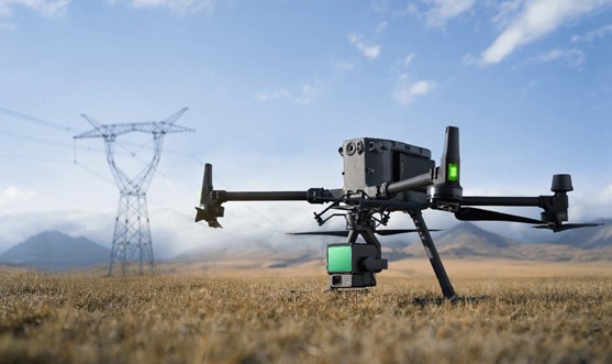
The DJI Zenmuse L2 can detect objects up to 450 meters at 50% reflectivity and 250 meters at 10% reflectivity. This LiDAR system combines a high-accuracy IMU and an RGB mapping camera on a 3-axis stabilized gimbal. The result is a powerful tool that creates precise 3D maps. The Zenmuse L2 captures incredible detail with point cloud rates of 240,000 points per second in single return mode. These rates go up to 1,200,000 points per second in multiple returns mode.
Professionals in Saudi Arabian cities like Riyadh, Jeddah, and Dammam will find the Zenmuse L2’s accuracy impressive. It offers horizontal precision of 5 cm and vertical precision of 4 cm at 150 meters. These features make it valuable to map commercial and residential areas across Saudi Arabia’s business sectors. On top of that, it works with DJI TERRA to provide a complete solution. The system creates detailed point cloud outputs and extracts ground points to generate DEM results.
This piece shows expert techniques to make the most of the Zenmuse L2’s capabilities. It covers everything from original flight planning to advanced post-processing. These methods will improve your mapping outcomes by a lot, especially when you have urban developments or detailed terrain analysis to complete.
Mastering Flight Planning for High-Quality 3D Mapping
The success of 3D mapping with the DJI Zenmuse L2 depends on proper flight planning. This LiDAR system comes with two scanning modes that work in different mapping scenarios. The repetitive scanning mode (70°×3° FOV) gives consistent and accurate results perfect for precision mapping. The non-repetitive scanning mode (70°×75° FOV) penetrates better through forests and helps inspect power lines while capturing facade details.
Project requirements determine the right flight parameters. Flat terrain mapping needs 80-150m altitudes with speeds of 10-12 m/s to achieve high accuracy. Projects that focus on speed can run at 150-200m and 12-15 m/s. Dense vegetation areas need slower speeds of 7-8 m/s to capture enough ground points.
Terrain following capabilities help get the best results in varied landscapes, particularly in commercial areas of Riyadh, Jeddah, and Dammam. This feature keeps a steady altitude above changing ground levels and ensures consistent data quality with uniform ground sampling distance. The right overlap settings make a difference – 75% frontlap and 75% sidelap typically provide better coverage of complex structures.
Return mode choice affects how well the system penetrates surfaces. The penta return mode receives up to five returns per laser beam, which works great for creating dense point clouds. Areas with big elevation changes need flight paths that run perpendicular to contour lines instead of parallel to spread points more evenly.
Expert Techniques for Field Data Collection and Quality Assurance
The DJI Zenmuse L2’s success in field operations depends on proper fine-tuning and quality checks. Users must enable “Calibrate IMU” to ensure accuracy before collecting data. This fine-tuning process needs to happen before flight tasks begin and should be repeated when countdown prompts appear during operations.
RTK status plays a vital role throughout the task. RTK Fix provides centimeter-level positioning accuracy, while Float or Single solutions result in lower accuracy. The system needs 13-15 well-distributed satellites across the sky to maintain a stable RTK Fix.
Task Quality Reports automatically generate after each flight. These reports show how long the LiDAR, camera, and IMU modules collected effective data. Different colors mark the RTK status along the route as Fix, Float/Single, or Invalid solutions. Extended Float/Single durations can benefit from Post-Processing Kinematic (PPK) calculations to improve positioning accuracy during data processing.
The DJI Pilot 2 app lets operators see up-to-the-minute point cloud models with four coloring choices: reflectivity, height, distance, and RGB. This instant feedback helps assess data quality while still at project sites in Riyadh, Jeddah, or Dammam.
The device needs a 60-second waiting period after data collection ends. Powering off or removing the microSD card too quickly can affect accuracy.
Advanced Post-Processing and Output Optimization
DJI Terra software helps process raw data from the DJI Zenmuse L2 with specific techniques that deliver the best results. This software is a vital tool that significantly improves accuracy. The “Optimize Point Cloud Accuracy” feature takes vertical accuracy from 4 cm to higher precision levels and improves horizontal accuracy from 8 cm.
The data processing starts when you launch DJI Terra and create a LiDAR Point Cloud task. You just need to import a folder with L2 data files (CLC, CLI, CMI, IMU, LDR, RTB, RTK, RTL, and RTS). Your computer should meet the minimum requirements because LiDAR processing uses significant computing power.
Projects in Riyadh and Jeddah can benefit from PPK calculations using D-RTK 2 Mobile Station or third-party base station data. The software recognizes compatible formats (.oem, .ubx, .obs, .rtcm) based on a set priority order.
DJI Terra can export precise point clouds in LAS, PLY, and PNTS formats after processing. The “Merged Output” feature helps combine multiple flight missions into one LAS file, which works great for complex projects in Dammam’s commercial areas.
The software also uses Ground Control Points (GCPs) to improve elevation accuracy and Check Points to verify data precision. Users can choose 3D formats, set output folder names, and decide whether to overwrite existing files based on their export needs.
Conclusion
You need to pay attention to every phase of the workflow to become skilled at using the DJI Zenmuse L2 – from original flight planning through field operations to post-processing. Professionals who follow these techniques will achieve superior mapping results with centimeter-level precision. Raw data becomes valuable 3D models through proper flight parameters, diligent field calibration, and advanced post-processing that serve many applications in Saudi Arabia’s urban landscapes.
The Zenmuse L2’s most important capabilities make it an exceptional tool for mapping professionals. It offers detection ranges up to 450 meters and point cloud emission rates up to 1,200,000 points per second. Users who maintain RTK Fix status during flights and use DJI Terra’s optimization features will consistently produce highly accurate deliverables that meet even the toughest project requirements.
The system proves especially valuable in Riyadh, Jeddah, and Dammam, where precise terrain modeling supports urban planning, infrastructure development, and commercial construction. Multiple return modes help professionals map challenging environments with unprecedented detail by penetrating vegetation.
Professionals who want to stay at the vanguard of mapping technology should check the latest DJI advances at Abdulrahman Alshareef Group. Their expertise can help improve the use of this powerful system in applications of all types.
The DJI Zenmuse L2 represents a breakthrough in available LiDAR technology. Users who master these expert techniques will discover its full potential and deliver exceptional 3D mapping results while optimizing their entire workflow.


